Geography of Mexico
|
Area
Total-1,972,550 km2 (761,610 sq mi) Land-1,923,040 km2 (742,490 sq mi) Water-49,510 km2 (19,120 sq mi) Coordinates-23°00′N 102°00′WCoordinates: 23°00′N 102°00′W Borders United States-3,141 km (1,952 mi) Guatemala-871 km (541 mi) Belize-251 km (156 mi) Coastlines-9,330 km (5,800 mi) Maritime claims Contiguous zone-24 nautical miles (44.4 km; 27.6 mi) Economic zone-200 nautical miles (370.4 km; 230.2 mi) Territorial sea-12 nautical miles (22.2 km; 13.8 mi) |
|
Geography
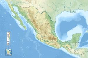
Mexico is bordered by the United States to the north and Belize and Guatemala to the southeast. Mexico is about one-fifth the size of the United States. Baja California in the west is an 800-mile (1,287-km) peninsula that forms the Gulf of California. In the east are the Gulf of Mexico and the Bay of Campeche, which is formed by Mexico's other peninsula, the Yucatán. The center of Mexico is a great, high plateau, open to the north, with mountain chains on the east and west and with ocean-front lowlands beyond.
Government
Federal republic.
A federal republic is a type of government made up of smaller areas such as states or provinces where the central government cedes certain powers to the individual areas for self-government purposes. The citizens of the federal republic elect their own representatives to lead them.
A federal republic is a type of government made up of smaller areas such as states or provinces where the central government cedes certain powers to the individual areas for self-government purposes. The citizens of the federal republic elect their own representatives to lead them.
History
At least three great civilizations—the Mayas, the Olmecs, and the Toltecs—preceded the wealthy Aztec empire, conquered in 1519–1521 by the Spanish under Hernando Cortés. Spain ruled Mexico as part of the viceroyalty of New Spain for the next 300 years until Sept. 16, 1810, when the Mexicans first revolted. They won independence in 1821.
From 1821 to 1877, there were two emperors, several dictators, and enough presidents and provisional executives to make a new government on the average of every nine months. Mexico lost Texas (1836), and after defeat in the war with the U.S. (1846–1848), it lost the area that is now California, Nevada, and Utah, most of Arizona and New Mexico, and parts of Wyoming and Colorado under the Treaty of Guadalupe Hidalgo. In 1855, the Indian patriot Benito Juárez began a series of reforms, including the disestablishment of the Catholic Church, which owned vast property. The subsequent civil war was interrupted by the French invasion of Mexico (1861) and the crowning of Maximilian of Austria as emperor (1864). He was overthrown and executed by forces under Juárez, who again became president in 1867.
From 1821 to 1877, there were two emperors, several dictators, and enough presidents and provisional executives to make a new government on the average of every nine months. Mexico lost Texas (1836), and after defeat in the war with the U.S. (1846–1848), it lost the area that is now California, Nevada, and Utah, most of Arizona and New Mexico, and parts of Wyoming and Colorado under the Treaty of Guadalupe Hidalgo. In 1855, the Indian patriot Benito Juárez began a series of reforms, including the disestablishment of the Catholic Church, which owned vast property. The subsequent civil war was interrupted by the French invasion of Mexico (1861) and the crowning of Maximilian of Austria as emperor (1864). He was overthrown and executed by forces under Juárez, who again became president in 1867.
General indicators

limate: varies from tropical to desert.
Terrain: high, rugged mountains; low coastal plains; high plateaus; desert.
Elevation extremes:
Land use:
Total renewable water resources: 457.2 km3
Natural hazards: Tsunamis along the Pacific coast, volcanoes and destructive earthquakes in the center and south, and hurricanes on the Gulf of Mexico and Caribbean coasts.
volcanism: volcanic activity in the central-southern part of the country; the volcanoes in Baja California are mostly dormant; Colima (elev. 3,850 m), which erupted in 2010, is Mexico's most active volcano and is responsible for causing periodic evacuations of nearby villagers; it has been deemed a "Decade Volcano" by the International Association of Volcanology and Chemistry of the Earth's Interior, worthy of study due to its explosive history and close proximity to human populations; Popocatepetl (elev. 5,426 m) poses a threat to Mexico City; other historically active volcanoes include Barcena, Ceboruco, El Chichon, Michoacan-Guanajuato, Pico de Orizaba, San Martin, Socorro, and Tacana
Environment – current issues: Natural fresh water resources scarce and polluted in north, inaccessible and poor quality in center and extreme southeast; raw sewage and industrial effluents polluting rivers in urban areas; deforestation; widespread erosion; desertification; serious air pollution in the national capital and urban centers along the US-Mexico border; land subsudence in Valley of Mexico caused by groundwater delpletion.
Environment – international agreements: Party to: Biodiversity, Climate Change, Climate Change-Kyoto Protocol, Desertification, Endangered Species, Hazardous Wastes, Law of the Sea, Marine Dumping, Marine Life Conservation, Ozone Layer Protection, Ship Pollution, Wetlands, Whaling.
Terrain: high, rugged mountains; low coastal plains; high plateaus; desert.
Elevation extremes:
- lowest point: Laguna Salada -10 m
- highest point: Pico de Orizaba volcano 5,700 m
Land use:
- arable land: 12.98%
- permanent crops: 1.36%
- other: 85.66% (2011)
Total renewable water resources: 457.2 km3
Natural hazards: Tsunamis along the Pacific coast, volcanoes and destructive earthquakes in the center and south, and hurricanes on the Gulf of Mexico and Caribbean coasts.
volcanism: volcanic activity in the central-southern part of the country; the volcanoes in Baja California are mostly dormant; Colima (elev. 3,850 m), which erupted in 2010, is Mexico's most active volcano and is responsible for causing periodic evacuations of nearby villagers; it has been deemed a "Decade Volcano" by the International Association of Volcanology and Chemistry of the Earth's Interior, worthy of study due to its explosive history and close proximity to human populations; Popocatepetl (elev. 5,426 m) poses a threat to Mexico City; other historically active volcanoes include Barcena, Ceboruco, El Chichon, Michoacan-Guanajuato, Pico de Orizaba, San Martin, Socorro, and Tacana
Environment – current issues: Natural fresh water resources scarce and polluted in north, inaccessible and poor quality in center and extreme southeast; raw sewage and industrial effluents polluting rivers in urban areas; deforestation; widespread erosion; desertification; serious air pollution in the national capital and urban centers along the US-Mexico border; land subsudence in Valley of Mexico caused by groundwater delpletion.
Environment – international agreements: Party to: Biodiversity, Climate Change, Climate Change-Kyoto Protocol, Desertification, Endangered Species, Hazardous Wastes, Law of the Sea, Marine Dumping, Marine Life Conservation, Ozone Layer Protection, Ship Pollution, Wetlands, Whaling.
Climate
The Climate in Mexico varies according to its topography. Along the coast (on both sides of the country) it is hot and humid, unbearably so in the summer. Inland communities at higher elevations such as Guadalajara (5200 ft above sea level) and in particular close-by Lake Chapala, are much dryer and more temperate.
Rio Grande
The Rio Grande rises in the western part of the Rio Grande National Forest in the U.S. state of Colorado. The river is formed by the joining of several streams at the base of Canby Mountain in the San Juan Mountains, just east of the Continental Divide. From there, it flows through the San Luis Valley, then south into New Mexico, passing through Española, Albuquerque, and Las Crucesto El Paso, Texas and Ciudad Juárez, Chihuahua. Below El Paso, it serves as part of the border between the United States and Mexico.The official river border measurement ranges from 889 miles (1,431 km) to 1,248 miles (2,008 km), depending on how the river is measured. A major tributary, the Rio Conchos, enters at Ojinaga, Chihuahua, below El Paso, and supplies most of the water in the border segment. Other well-known tributaries include the Pecos and the smaller Devils, which join the Rio Grande on the site of Amistad Dam. Despite its name and length, the Rio Grande is not navigable by ocean-going ships, nor do smaller passenger boats or cargo barges use it as a route. It is barely navigable at all, except by small boats in a few places; at its deepest point, the river's depth is only 60 feet (18 m), and its average depth is far less: about ten feet.

Colorado River

The Colorado River (Spanish: Río Colorado) is one of the principal rivers of the Southwestern United States and northern Mexico (the other being the Rio Grande). The 1,450-mile (2,330 km) Colorado River drains an expansive, arid watershed that encompasses parts of seven U.S. and two Mexican states. Starting in the central Rocky Mountains in the U.S., the river flows generally southwest across the Colorado Plateau and through the Grand Canyon before reaching Lake Mead on the Arizona–Nevada border, where it turns south toward the international border. After entering Mexico, the Colorado approaches the mostly dry Colorado River Delta at the tip of the Gulf of California between Baja California and Sonora.
Home to 11 U.S. National Parks, which include dramatic canyons and whitewater rapids, the Colorado River system is also a vital source of water for agriculture and urban areas in much of the southwestern desert lands of North America.[6] The river and its tributaries are controlled by an extensive system of dams, reservoirs, and aqueducts, which in most years divert its entire flow to furnish irrigation and municipal water supply for almost 40 million people both inside and outside the watershed.[7][8] The Colorado's large flow and steep gradient are used for generating hydroelectric power, and its major dams regulate peaking power demands in much of the Intermountain West. This intensive consumption has dried up the lower 100 miles (160 km) of the river, such that it has reached the sea only a few times since the 1960s.
Home to 11 U.S. National Parks, which include dramatic canyons and whitewater rapids, the Colorado River system is also a vital source of water for agriculture and urban areas in much of the southwestern desert lands of North America.[6] The river and its tributaries are controlled by an extensive system of dams, reservoirs, and aqueducts, which in most years divert its entire flow to furnish irrigation and municipal water supply for almost 40 million people both inside and outside the watershed.[7][8] The Colorado's large flow and steep gradient are used for generating hydroelectric power, and its major dams regulate peaking power demands in much of the Intermountain West. This intensive consumption has dried up the lower 100 miles (160 km) of the river, such that it has reached the sea only a few times since the 1960s.
Day of the dead
he Day of the Dead (El Día de los Muertos in Spanish) is a Mexican and Mexican-American celebration of dead ancestors which occurs on November 1 and November 2, coinciding with the similar Roman Catholic celebrations of All Saints Day and All Souls Day. While it is primarily viewed as a Mexican holiday, it is also celebrated in communities in the United States with large populations of Mexican-Americans, and to a lesser extent elsewhere in Latin America. Despite the morbid subject matter, this holiday is celebrated joyfully, and though it occurs at the same time as Halloween, All Saints Day, and All Souls Day, the mood of The Day of the Dead is much lighter, with the emphasis on celebrating and honoring the lives of the deceased, rather than fearing evil or malevolent spirits. The origins of the celebration of The Day of the Dead in Mexico can be traced back to the indigenous peoples of Latin America, such as the Aztecs, Mayans Purepecha, Nahua and Totonac

Tulum beach
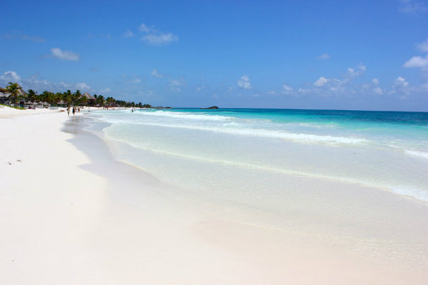
is the site of a pre-Columbian Mayan walled city serving as a major port for Cobá.The ruins are situated on 12-meter (39 ft) tall cliffs, along the east coast of the Yucatán Peninsula on the Caribbean Sea in the state of Quintana Roo, Mexico.Tulum was one of the last cities built and inhabited by the Maya; it was at its height between the 13th and 15th centuries and managed to survive about 70 years after the Spanish began occupying Mexico. Old World diseases brought by the Spanish settlers appear to have resulted in very high fatalities, disrupting the society and eventually causing the city to be abandoned. One of the best-preserved coastal Maya sites, Tulum is today a popular site for tourists.
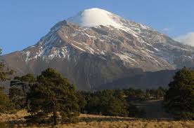
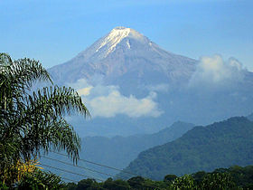
Pico de Orizaba
|
Elevation-5,636 m (18,491 ft) Prominence-4,922 m (16,148 ft) Isolation-2,690 kilometres (1,670 mi) Parent peak-Mount Logan Listing
Coordinates-19°01′48″N 97°16′12″W |
|
pico de Orizaba volcano (Volcán Citlaltépetl) is a large active stratovolcano, Mexico's highest mountain and the highest volcano of North America. It is located at the southern end of Citlaltépetl–Cofre de Perote Volcanic Range, and the only volcano in this area with historic activity.
Historical eruptions have consisted of moderate explosive activity and the effusion of dacitic lava flows. The latest eruption of the volcano were in 1545, 1566, 1630 and 1687.
Historical eruptions have consisted of moderate explosive activity and the effusion of dacitic lava flows. The latest eruption of the volcano were in 1545, 1566, 1630 and 1687.